
 Service Map
Today is: , Time: ,
Name-day: Pankracego, Renaty, Ryszarda
Service Map
Today is: , Time: ,
Name-day: Pankracego, Renaty, Ryszarda
(walk time circa 4h)
The start of the route in Złote Mountains at the borderline, then passing the hostel, to asphalt road to Bialskie Mountains. After 1h we come down the road to get to Czernica. From Czernica we can admire large part of Sudety with Czech Jeseniki. Going down from Czernica we get back to the asphalt road and with the blue route we get to Wielkie Rozdroże, where the junction of forest roads from Bielice, Młynowiec, Stara Morawa is. The route leads to Przełęcz Sucha with the place for rest and tourist shed. This is a junction route not constituting the Main Route of Sudety. The route begins in Zote Mountains, at the border with Czech Republic, then gets into Bialskie Mountains.
Picturesque, visually attractive, long route, running through the order trail in Bialskie Mountains (from the Primeval Forest of Śnieżna Białka), through the border crossing of unfrequent traffic with the Czech Republic on the pass of Płoszczyna. Interesting and challenging climb to Śnieżnik.
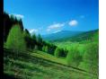
This is the part of the international tourist route Atlantic – The Black Sea (E3). On the given part it runs through Złote Mountains, Bialskie Mountains and the Massif of Śnieżnik.
The route starts at the tourist shed. Then we take the road left and after 15min. turn into forest track of Albrecht. After 1h we reach the junction with the green route, from this place to Międzygórze about 50min.
(walk time circa 4 h)
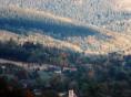
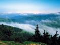
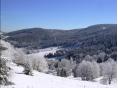
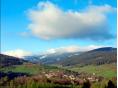
One of the most frequented routes starting At Stronie. It begins on the bus stop in the Kościuszki Street, then passing the Town Hall and turning into Sportowa Street. Passing the majestic neogothical funeral house on the right, which is situated in the evangelical church of 1915. Next to the chapel renovated stone votive poll from 1674. On the left, behind the stadium ruins of the chapel of St. Onuphry dating to 1734-35, passing the dam on the river Morawka from 1910 and the storage reservoir. Next, the route turns to Krzyżnik (710m) and traverses its eastern slope as well as the slope of Janowiec (910m). The route goes down to Kletno, taking the asphalt road in the direction of the Niedzwiedzia Cave. On the right it passes the valley of Kleśnica, old mounds rich in interesting minerals, large parking place, and old quarry pits on the right. Behind the gate of Reserve the route turns right, reaching the beginning of Krasowa Educational Route first, then to the Niedzwiedzia Cave. After leaving the cave the route climbs the Gęsia Gardziel and after 45min reaches the flattening of Żmijowiec, where it joins the red-labelled route from Czarna Góra. Further, the red route leads on the stony road to the Alp under Śnieżnik, where PTTK youth hostel is situated. From here, the green route reaches the peak in 30min. This is the highest peak (1425m) in Easter Sudety on the Polish side, from which you can admire the panoramic view of the Sudety.
Stronie-Przełęcz Puchaczówka-Czarna Góra-Igliczna_Międzygórze
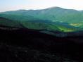
The route starts ST the railway station. Going through the Kościuszki Street you reach the Kościelna Street, where the route runs up to The Church of The Mother of The Good and Queen of Poland and St. Maternus. Then, through narrow Turystyczna Street to Stronie, up next to the shop, passing the old marble quarry. It reaches the pass behind Chłopek, where it meets red-labelled route from Lądek Zdrój. Then it passes the chapel by the road to Bystrzyca Kłodzka and reaches the tourist shed in the juncture of the routes. Then it leads through the red-labelled route to the peak of Czarna Góra (1205m.), from where you can admire the views on Stronie Śląskie, Lądek Zdrój, Złote Mountains and Bialskie Mountains as well as on the valley of Nysa Kłodzka, Bystrzyckie Mountains and Kłodzka Valley. The route goes down to the pass Under Jaworowa Kopa, where green signs lead down and right, cross the road to transmitter on the slope of Czarna Góra and go straight through the woods to the chapel near Lesieniec. Through the lea the route goes to Lesieniec (868m.), goes down to Krzyż, from where after 10 minutes you reach the hostel and Sanctuary of Snowy Maria on the slope of Igliczna (847m.).Then, the green route leads down quite steeply to the dam on river Wilczka and to Międzygórze.
The route starts ST the railway station. Going through the Kościuszki Street you reach the Kościelna Street, where the route runs up to The Church of The Mother of The Good and Queen of Poland and St. Maternus. Then, through narrow Turystyczna Street to Stronie, up next to the shop, passing the old marble quarry. It reaches the pass behind Chłopek, where it meets red-labelled route from Lądek Zdrój. Then it passes the chapel by the road to Bystrzyca Kłodzka and reaches the tourist shed in the juncture of the routes. Then it leads through the red-labelled route to the peak of Czarna Góra (1205m.), from where you can admire the views on Stronie Śląskie, Lądek Zdrój, Złote Mountains and Bialskie Mountains as well as on the valley of Nysa Kłodzka, Bystrzyckie Mountains and Kłodzka Valley. The route goes down to the pass Under Jaworowa Kopa, where green signs lead down and right, cross the road to transmitter on the slope of Czarna Góra and go straight through the woods to the chapel near Lesieniec. Through the lea the route goes to Lesieniec (868m.), goes down to Krzyż, from where after 10 minutes you reach the hostel and Sanctuary of Snowy Maria on the slope of Igliczna (847m.).Then, the green route leads down quite steeply to the dam on river Wilczka and to Międzygórze.
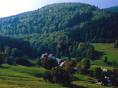
A very interesting route passing through less known parts of Bialskie Mountains, with magnificent views. It starts in Stronie on the bus stop at Kościuszki Street, then it leads left through the bridge on Morawka river and Mickiewicza Street, reaching Goszów.
With yellow signs it turns right through the bridge on Biała Lądecka river, to Trout Paradise trout culture. It turns left with the valley of Popówka,up next to old forester’s lodge, with the narrow path straight, next to the ruins of old buildings. It rexhes the forest stony road and turns right with the signs. Traverses Łysiec. On the right, picturesque view of Bialskie Mountains (with Suszyca, 1047m.) and the Massif of Śnieżnik. It reaches the Pass of Dział (922m.), where you can find a tourist shed and the juncture of the routes. Then it goes with the yellow route and after 30 min. suddenly turns left, up to the peak of Czernica (1083m.), which is a woodless dome, where you can see a magnificent view of Sudety. With the ridge of Czernica it reaches Płoska (1035m.) and then down through the forest to the road to Bielice, where it meets green route and reaches the village.
Access route to the blue route Nowa Morawa-Kamienica-Alp under Śnieżnik, and to green route Bielice- Alp under Śnieżnik.
The other direction of the same route:from the bus stop to the centre of the village. We go through Bolesławów. The route goes through narrow path next to the church, up to Zawada (807m.) and to Staromorawska Pass, where we meet bl;ue routes of Nowa MOrawa-Kamienica. Then, on the road to Płoszczyna pass.