
 Service Map
Today is: , Time: ,
Name-day: Haliszki, Lody, Przybysłšwa
Service Map
Today is: , Time: ,
Name-day: Haliszki, Lody, Przybysłšwa
Stronie Śląskie – Młynowiec – Dział Pass (922 meters) – Sucha Pass (1006 meters) – Nowa Morawa – Bolesławów – Stara Morawa – Stronie Śląskie
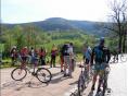
Route course:
The starting point is Sportowa Street opposite the Borough and Town Office in Stronie Śląskie. We follow the yellow trail blazes that lead us southwards. A few hundred meters further we turn left and cross the Morawka river on the dam. We cross Morawska Street and go towards the residential area. We stick to the main road all the time, and finally turn right in Sudecka Street. The road leads us to the village called Młynowiec, and it’s an old tourist trail known as “Albrecht Weg” (the Albrecht’s Road) joining Młynowiec and Stronie Śląskie. The road slightly turns and goes gently upwards. From the curve we can admire views of the Golden Mountains and the Snieżnik Massif. We come to Młynowiec. At the end of the village the district road ends, and the forest road begins. Now we ride the so-called Mill Road along the Młynówka valley. We keep climbing the rocky path lining the main road. The Bialska Loop joins our route from the right. We take the road to the left and begin to climb up the steep hill. The road has a lot of bending curves. Loose stones lying all over the surface make it even more difficult. We arrive at Dział Pass (922 meters), where we can take some rest and refresh ourselves before we move on. Available facilities have a resting place and a shelter. As we set off again, we take an asphalt road, and then we take the first right and follow the blue trail blazes. We climb up the gentle slope. Amazing views of the Śnieżnik Massif are to be seen from the bends. The road is winding in hairpin curves. We pass the potable water spring on the left, then Zawodzisko (the highest point in the area – 995 meters), and then come to the Great Crossroads (960 meters) – an intersection of five roads.
We move on along the asphalt road as the red and blue blazes lead us to another resting place on Sucha Pass (1006 meters). A shelter and benches for tourists are also available there. Below the intersection, a view of Mt. Śnieżnik (1425 meters)is revealed to our eyes. From now on, we will only be descending – good news for the exhausted! First, we follow the blue blazes down the slope, then we let them turn to the right, but we keep going straight along the rocky path. The path leads to the right. We traverse the slope, and come to Marion’s Road. Then we go to the left following the blue blazes, along the road to Nowa Morawa where the forest road meets the asphalt road. Going left, we could get to the border crossing for tourists between Poland and the Czech Republic, however we turn to the right and ride along the Morawka River valley across the village. The next village on our route is Bolesławów. We take the paved road, and keep riding along for a few hundred meters, but we don’t forget to turn right from the market square. We cross the intersection and go straight to the Stara Morawa village. We should always see the Morawka River on the right. We cross another intersection and still go straight. The district road has been rebuilt, which should make our life easier. We pass the reservoir on the left, and the dam on the right. We keep on riding until we reach the Town Office, which is the end of our journey.
Attractions:
The Bialskie Mountains are one of the biggest serried mountain ranges and uninhabited forest areas in the Lower Silesia. Vertically leveled plateau of app. 1,000 meters is varied with relatively low, sturdy mountain tops. Ridges and slopes are overgrown by dense, spruce forests growing in the lower parts of the mountains. Among the trees we can find the remnants of primeval conifer and broadleaf forests. Spruces, larches, beeches and sycamores occur most frequently. We find ourselves in a barely cultivated area which makes the forest look primeval and wild. Deer, boars, roes and mufflons are representatives of large animals. The list of common forest inhabitants includes foxes, martens, polecats, fox and red squirrels, hares and hedgehogs. Silence and seclusion are the most favoured conditions for the nesting birds, in this case the black stork, the black grouse, capercaillie and hazel grouse. A grid of mountains roads and paths fosters the development of cycling tourism. From their saddles, the bikers can explore the wildlife and admire the landscapes.
It is hard to imagine that the village of Bolesławów used to be a town in the past. Originally it was established as a free mining colony. The colony was given a status of a town in 1581 by Wilhelm von Oppersdorf, the minter of the king of Czechia. The former name of the town – Wilhelmsthal (the Wilhelm’s Valley) – was given after its founder. The town had a market square, three streets, young miners’ lodges and a wooden church. The Miners’ guild was also established in 1582. The town had also its seal. Silver and iron were explored until the early 17th Century, but the local ores proved to be small. It is the period when the gradual decline of the town began. The Thirty Years’ War and plagues contributed to loss of the town’s significance. In 1891, Bolesławów was downgraded to a village again. The collapse of the mining industry was replaced by the development of tourism. In the early 19th Century Bolesławów was described as a tourist attraction in the guidebooks. Further development of the grid of roads in the Bialskie Mountains made the village a good starting point for the trips. In the 1920s the village became a ski resort. Ski lessons were available in Bolesławów, and a ski-jumping hill, a coast and the skiing slopes were located in the area.
Before the war, the place was inhabited by ca. 500 people, and the village was a popular resort. Bolesławów’s decline began after 1945, together with the opening of the uranium mine in the nearby village of Kletno, which resulted in restriction of colonization. The mine was closed in the 70s and Bolesławów became a resort again. Plants and factories used to have their holiday centres here, which are now being replaced by lodging houses and hotels. New skiing facilities were established (e.g. lifts in Kamienica) to bring the skiing amateurs back just as it was before the war.